Department for Environment and Water
  • Home
  • About us
    • Boards & committees
    • Our goals
    • Our plans
    • Our reports
    • First Nations partnerships
    • Legislation
    • Freedom of information
    • Public Interest Disclosures
    • Media contacts
  • Topics
    • Animals and plants
    • Fire management
    • Climate Change
    • Coasts
    • Compliance
    • Crown land
    • Biodiversity
    • Flinders Ranges World Heritage nomination
    • Flood
    • Green Adelaide
    • Heritage
    • Landscape SA
    • Native vegetation
    • Park management
    • Science
    • Soil and land management
    • Water and River Murray
  • Our places
    • National parks
    • Wilderness protection areas
    • Marine parks
    • Beach driving
    • Cleland Wildlife Park
    • Seal Bay Conservation Park
    • Naracoorte Caves
    • Botanic Gardens and State Herbarium
    • State Flora
    • Adelaide Gaol
    • Arkaroola
  • Get involved
    • Working with us
    • Volunteering
    • Grants & funding
    • Have your say
    • Good Living blog
    • Stay informed
    • Unsolicited proposals
    • Public notices
    • What to explore in 2024
  • Licences & permits
    • Wildlife permits
    • Animals in research & teaching
    • Animals in sport – Rodeo Permits
    • Commercial tour operator licences
    • Customer accounts
    • Planning for a development
    • Crown land application forms and fees
    • Event agreements
    • Filming & photography
    • Heritage archaeology permits
    • Hunting permits
    • Native vegetation clearance forms
    • Plant permits
    • Scientific research permits
    • Shipwreck dive permits
    • Water licence and permit forms
  • News
  • Contact us
Topics
  • Animals and plants
    • Living with wildlife
      • Snakes
      • Possums
        • Managing possums
      • Swooping birds
      • Wombats
        • Managing wombats
        • Protection for wombat burrows
      • Koalas
        • Living with koalas
        • Koala conservation and management
          • Managing koala populations in South Australia
        • Koala Plates
      • Grey-headed flying foxes
      • Little Corellas
      • Seals
        • Frequently asked questions
      • Whales and dolphins
        • Adelaide Dolphin Sanctuary Investigation
    • Keeping native animals
    • Threatened species and ecological communities
    • Sustainable use of animals and plants
      • Hunting
        • Aboriginal hunting & gathering
          • On reserves
          • Commercial
        • Bow and crossbow hunting
        • Hunting feral animals
        • Native bird hunting
          • Quail hunting
          • Duck hunting
      • Commercial kangaroo harvesting
        • Quotas & harvest data
        • Kangaroo Management Reference Group
    • Helping and protecting wildlife
      • Helping wildlife
      • Feeding wildlife
      • Wildlife disease and hazards
      • Helping wildlife in emergencies
    • H5 avian influenza (bird flu)
    • Moving native animals
      • Translocating native animals for conservation
    • Using animals in research and teaching
      • Research & teaching licences
        • Applying for a licence
      • Other permits & approvals
      • Animal ethics committees
    • Animal welfare
      • Animal welfare legislation
        • Animal Welfare Act Review
      • Codes of practice
        • Welfare of animals
        • Humane destruction of wildlife
      • Animal Welfare Advisory Committee
      • Oiled Wildlife Response
    • Animal and plant laws
    • Developing a Cat Management Strategy for South Australia
  • Fire management
    • Upcoming prescribed burns
    • Stay informed
    • What are prescribed burns?
      • How prescribed burns are planned
      • Burning on private lands
      • Prescribed burning FAQs
      • Smoke management
    • Managing bushfire risk
      • Fire bans and restrictions
      • Reducing fire risk on your property
      • How do we manage fuel hazard?
        • Reducing bushfire fuel by slashing
      • Fire management in a changing climate
      • Fire management and the law
    • Fire and the environment
      • Ecological strategies and guidelines
      • Eco burns in Fleurieu swamps
      • Burning banksias to save them
    • Fire science and planning
      • Fire research
      • Fire behaviour
      • Fire monitoring
      • Fire management plans
        • Current fire management plans for South Australian parks
        • Draft AMLR Fleurieu fire management plans
        • Draft Murray Mallee Fire Management Plan
      • Fire management maps
    • Work with us
      • Annual recruitment
      • Term pool register
      • Essential requirements
    • About us
    • Contact us
  • Climate Change
    • South Australian Government engagement in COP29
    • Government action on climate change
      • Adapting to climate change
      • Blue Carbon
      • Carbon sequestration
      • National and international engagement
      • South Australia’s Climate Change Opportunity
      • Building Upgrade Finance
      • Regional Climate Partnerships
      • Climate Change Sector Agreements
    • How climate change is affecting South Australia
    • South Australia’s greenhouse gas emissions reporting
      • Reducing Greenhouse Emissions through mitigation
    • Climate science, information and resources
      • Latest climate projections for SA
      • Climate science knowledge and tools
    • Premier’s Climate Change Council
      • Premier’s Climate Change Council members
      • SA Climate Leaders Awards
      • 2024 SA Climate Leaders Award winners
      • 2022 SA Climate Leaders Award winners
      • 2020 SA Climate Leaders Award winners
      • 2018 SA Climate Leaders Award winners
    • Stay informed and get involved
      • Climate Action SA e-newsletter
      • Events and videos
      • Resources for business
      • Resources for community and educators
  • Coasts
    • Adelaide Beach Management Review - dredging trial
      • Adelaide Beach Management Review - Shortlisted options
    • Managing Adelaide's Beaches
      • Adelaide beach works
      • Frequently asked questions
        • Delivering external sand to West Beach
        • West Beach dune restoration project
      • Sand pumping along Adelaide's coast
        • How the system works
        • Sand transfer locations
          • Glenelg to Kingston Park
          • Torrens Outlet to West Beach dunes
        • Technical information
    • Explore and learn
      • Australia’s biggest seagrass restoration project is happening in SA
      • Beaches aren’t just for sunbathing!
      • Coastal wetlands the ‘link’ between land and sea
      • Restoring Adelaide’s lost shellfish reefs
    • Protecting our coastal environment
      • Ongoing activities and strategies
      • Monitoring our beaches and coast
    • Latest news
    • Grants
      • Coast Protection Grants
        • Coast protection grant past recipients
        • Coast protection grant recipient case studies
      • Community Participation Grants
        • Community Participation Grants - past grant recipients
    • Coastal development applications
      • How coastal hazards impact coastal development
      • How sea level rise impacts coastal development
    • Coast Protection Board
      • Coast Protection Board Members
      • Policies, reports and meeting minutes
      • Previous years minutes
      • Sustainable development
      • Climate Science Advisory Committee
      • Freedom of Information requests
        • Coast Protection Board FOI Disclosure Log
    • St Kilda mangroves
    • Research, reports and policies
    • Contact DEW's coastal management team
  • Compliance
    • Our compliance approach
    • Our compliance strategy
    • Water compliance
  • Crown land
    • South Australia's Crown land
      • Managing Crown land
      • Native title
      • Community consultation
    • Accessing Crown land
      • Waterfront and coasts
      • Developing on Crown land
    • Crown land tenure
      • Licences
      • Leases
      • Dedication
      • Easements
    • Purchasing Crown land
    • Application forms and fees
      • Frequently Asked Questions
    • Contact us
    • Property professionals
      • Local councils and Crown land
      • Government agencies and Crown land
      • Conveyancers, Solicitors and Real Estate Agents
    • Public notices and consultation
    • Shacks on Crown Land and national parks
  • Biodiversity
    • About biodiversity
    • Biodiversity Act
    • What are we doing to improve biodiversity?
    • Threatened species & ecological communities
      • Threatened species
        • Plants
          • Orchids
            • Caladenia intuta
            • Pterostylis despectans
            • Thelymitra epipactoides
          • Dicotyledons general
            • Phebalium lowanense
            • Prostanthera eurybioides
          • Sedges & rushes
          • Monocotyledons general
          • Daisies
          • Legumes
        • in South Australia
        • Animals
          • Native freshwater fish
      • Threatened ecological communities
        • In South Australia
      • Recovery planning
        • Recovery actions
        • Plants
        • Animals
          • Land mammals
          • Marine mammals
          • Birds
          • Reptiles
          • Freshwater fishes
        • Ecological communities
      • Nature conservation legislation
      • Conservation status of threatened species
      • Regional & significant projects
        • Regional Species Conservation Assessment Project
  • Flinders Ranges World Heritage nomination
    • The Flinders Ranges World Heritage story
    • The benefits
    • The science
    • Cultural heritage and First Nations involvement
    • The nomination process
    • Nomination status
    • Community engagement
    • News and information
    • Frequently Asked Questions
  • Flood
    • Learn about flooding
      • Flood types
      • Flood risk
      • Flood history
    • Flood Awareness Map
    • Warning arrangements
    • Planning and roles
    • Flood Projects
      • Current projects
        • Gawler River flood management
        • Levee bank management
        • Dam safety management
        • Flood hazard mapping and assessment
        • Flood information management
    • Resources
      • Private dam safety and maintenance
      • Useful links for SA floods
  • Green Adelaide
  • Heritage
    • About us
      • Heritage SA
      • Get involved
    • SA Heritage Council
      • Heritage greetings through photos
      • Agendas & minutes
        • archive page
      • News
      • Meetings
      • Permits
      • Policies & procedures
      • Strategic Plan
      • Report on Heritage Protection 2020
      • Freedom of Information requests and Council Statement
        • FOI Disclosure Log
          • SA Heritage Council Disclosure Log
      • Reconciliation
      • Report on Heritage Protection 2022
      • Historic Themes of South Australia
      • Celebrating 150 meetings
    • Notifications
    • Frequently asked questions
    • SA Heritage Register and Surveys
      • Entries & confirmations
        • Submissions
      • Making a submission
      • Nominating a heritage place
      • Nominating an Object
      • Assessing heritage
      • Listing a heritage place
      • Heritage surveys
    • Heritage News and Events
      • Heritage Photo Competitions
        • Heritage SnAps Photo Competition 2021
          • Terms and conditions
          • Prizes
          • Top 20 finalists
        • Heritage SnAps photo competition 2020
          • Top 20 finalists
        • Essence of Heritage photo/video competition 2019
        • Heritage SnAps photo competition 2018
        • Sea Pixels photo competition 2017
      • Important changes to Historic Shipwreck legislation
      • The Edmund Wright Trail
    • Heritage Grants
      • Government Owned Heritage Fund
        • Glossary of terms
    • State Heritage Areas
      • Heritage Protection
      • Arckaringa Hills
      • Belair National Park
      • Beltana
      • Burra
      • Colonel Light Gardens
      • Gawler Church Hill
      • Goolwa
      • Hahndorf
      • Innamincka/Cooper Creek
      • Mintaro
      • Moonta Mines
      • Mount Gambier Cave Gardens
      • Mount Gambier Volcanic Complex
      • Mount Schank
      • Mount Torrens
      • Penola
      • Port Adelaide
    • Heritage venues and places to visit
      • Activating Heritage
      • Heritage Tourism Strategy
      • Cummins House
      • Heritage accommodation
      • Heritage trails
      • Torrens Parade Ground
      • Torrens Island Quarantine Station
    • Conserving our heritage
      • Adaptive reuse
      • Awards
      • Burra Charter
      • Protection and legislation
    • Owning a heritage place
      • Getting the right advice
      • Insuring your heritage place
      • Living in a State Heritage Area
      • Owning a heritage object
    • Heritage trades and consultants
    • Archaeology
    • Maritime heritage
      • Shipwrecks of South Australia's West Coast
      • Ethel Shipwreck Time-Lapse
      • Managing maritime heritage
        • Protected zones
          • Zanoni
          • Ex-HMAS Hobart
          • South Australian
        • Reporting a shipwreck or underwater cultural heritage
        • Permits
        • Shipwrecks and development
        • Legislation
      • Register of Historic Shipwrecks
        • Relics
        • Guide to using the AUCHD for shipwreck research (search options)
      • Visiting maritime heritage places
        • Shipwreck trails
          • Underwater Heritage Trail
          • Garden Island
          • Investigator Strait
          • Jervois Basin
          • Kangaroo Island
          • Port Elliot
          • River Boat Trail
          • Southern Ocean
          • Wardang Island
        • Ships' graveyards
          • Ardrossan
          • Cowell
          • Glenelg
          • Goat Island
          • Kangaroo Island
          • Port Adelaide
          • Port Augusta
          • Port Flinders
          • Port Lincoln
          • Port Noarlunga
          • Port Pirie
          • Port Stanvac
          • Stenhouse Bay
          • Whyalla
          • Yankalilla Bay
      • Frequently Asked Questions
      • Get involved
    • Contact us
  • Landscape SA
    • Pastoral leases in South Australia
      • Pastoral Unit
      • Managing your pastoral lease
      • Pastoral lease tenure forms
      • Public Access Routes to pastoral land in South Australia
      • Public Access Routes and sites of interest
      • Public Access Route Repair Program
        • Public Access Route review
    • Independent review of the Landscape South Australia Act 2019
  • Native vegetation
    • Protecting & enhancing
      • Heritage Agreements
        • Native Vegetation Heritage Agreement Grant Program
          • Training Opportunities
        • Heritage Agreement quick application form
      • Revegetate and restore habitat
      • Change Detection Program
    • Interactive Guide for Native Vegetation
    • Clearing Native Vegetation
      • New dwelling or building
      • Residential subdivision
      • Around an existing building or dwelling
      • Fences: maintain existing or establish a new fence
      • Fire prevention
      • Maintain agriculture, forestry or farming
      • Ecological restoration
      • Dam: create new or expand existing
      • Clearance application forms
      • Clearance application register
      • Pathways for clearance approval
        • Risk assessment pathway
      • Mitigation Hierarchy
      • Vegetation assessments
      • Report a suspected illegal clearance
      • Maps
      • Grazing: ongoing practices
      • Grazing: changed practices
      • Landscape management problems or plant and animal control
      • Bushfire preparedness
    • Consultations
      • Make your feedback count
      • Frequently asked questions
      • Consultation outcomes
    • Offsetting
      • How to offset a clearance
      • Turn your native vegetation into income
        • Native Vegetation Credit Register
        • Biodiversity Credit Exchange
          • Frequently asked questions
      • Become a Third Party Provider, broker or consultant
    • Accredited consultants
    • Developers, major projects & mining
    • Legislation and administration
    • Contact
      • Native Vegetation Council's eNewsletter
  • Park management
    • Co-management of parks
      • Aboriginal heritage
    • Statewide park strategies
      • Plans, strategies and policies in preparation
      • Park management plans
      • Nature-based tourism plan
      • Healthy Parks Healthy People SA
        • Five Ways to Wellbeing in Nature
        • Connection to Country for Aboriginal Health and Wellbeing
    • Statewide Trails Strategy
    • New parks & park additions
      • CARRS Program
      • Glenthorne National Park-Ityamaiitpinna Yarta
        • Memorandum of Understanding
    • Parks boundaries
    • Regional reserves
    • Commercial Leases & Licences Register
    • Nature-based tourism proposals
      • Lincoln National Park proposal
    • Public Land Stewardship Project
      • Willunga Creek
      • Gawler Buffer
      • Highbury Aqueduct Reserve
        • Stormwater management project 2023
      • Highbury Aqueduct Reserve
      • Mount Osmond Reserve
    • Beetaloo Reservoir Reserve
      • Conditions of access - Beetaloo Reservoir
  • Science
    • Science & research
      • State Herbarium
        • History
        • Governance & role
        • Policies
        • Collaborations
        • Collections
          • Vascular plants
          • Non-vascular plants
          • Access to collections
        • Research
          • Main research themes
          • Projects & opportunities
          • Phycology Unit
          • Research facilities
        • Resources
          • Publications
            • Journal of the Adelaide Botanic Gardens
            • Links
            • How to order
            • Flora of SA
          • Australia's Virtual Herbarium
        • Our people
          • Expertise
          • Volunteers
      • Seascapes, landscapes & communities
        • Marine and coastal habitat mapping
        • Native vegetation mapping techniques
        • Native vegetation mapping
        • Wetland inventories and mapping
        • Landscape restoration
          • Current restoration projects
          • Publications
          • Partnerships
        • Coastal & marine restoration
      • People in the environment
      • Ecological processes
        • Seed ecology
        • Wetland ecology
        • Disturbance ecology and fire
        • Marine ecology and systems
      • Monitoring, evaluation & analysis
        • Analysis
        • Monitoring
          • Climate change monitoring
      • Publications
        • NVC Research Grant final reports
      • Women in Science
        • Melissa White
        • Jamie Hicks
        • Angela Pestell
        • Sophie Bass
      • Wildlife Ethics Committee
      • Policies for wildlife research
    • Information & data
      • BioData SA
      • Data collection & management
      • Biological Databases of SA
        • Information sharing
      • Biological Survey of SA
        • Biological surveys
          • Regional surveys
          • Targeted & smaller area surveys
      • Census of SA plants, algae & fungi
      • Census of SA vertebrates
    • Partnerships
      • Working with us
    • Mapland
      • Maps
        • Emergency Services Map Books
        • Emergency Services Map Book – single map book pages
        • Emergency Services Map Books – Wall Maps
        • Emergency Services Map Book – Regional Wall Maps
        • Topographic and Cadastral maps
        • Cadmaps
        • Cycling Maps
      • Bushwalking maps & publications
      • Aerial photography
      • Spatial GIS data
      • Contact Mapland
      • MapFinder
    • Mapland
    • Citizen Science
      • Grants and Awards
    • NatureMaps
    • WaterConnect
    • Enviro Data SA
  • Soil and land management
    • Sustainable soil and land management
    • Soil health and condition
      • Soil Erosion Protection
        • Erosion protection field surveys
        • Satellite erosion protection monitoring
        • Satellite monitoring of seasonal conditions
        • Management of soil erosion risk
      • Soil acidity
        • Soil acidity - Management of risk
      • Land salinity
        • Land salinity monitoring and trends
      • Soil carbon
        • Soil carbon monitoring and trends
        • Managing to enhance soil carbon
      • Crop water use efficiency
        • Managing to enhance crop water use efficiency
      • Soil biological health
        • Managing to enhance soil biology
      • Land manager knowledge and practices
    • Maintaining healthy soils
      • Soil modification
      • Managing Dry Conditions
      • Climate Change Adaptation
        • Wheat production & erosion risk
      • Carbon sequestration from soils
      • Carbon Sequestration from Revegetation
      • Perennial production systems
        • FloraSearch Project
      • Soil suitability for irrigation
      • Soils and habitat restoration
    • Soils of South Australia
      • Soil and land information
      • Mapping soil & land
      • Describing soil & land
        • SA-format attributes
        • National-format attributes
      • Assessing land use potential
        • Land use potential models
      • Land suitability for agriculture
    • Useful links
  • Water and River Murray
    • Licences, allocations and markets
      • Water Register
        • Water Register FAQs
      • mywater Portal
        • mywater FAQs
      • Licences, accounts and metering
        • Water metering and reporting
        • Water fees, penalties and compliance
        • Water entitlements vs allocations
        • Adelaide Plains MAR Scheme licences
      • Water allocations and carryover
        • Current allocations
        • Water calculator
        • Past allocations
        • Carryover and other options
          • Carryover for the River Murray Prescribed Watercourse
          • Carryover for the Adelaide Plains
        • How River Murray water is allocated
        • Review of allocation announcement process
      • Water markets and trade
        • Buying and selling water
        • Frequently asked questions about River Murray water trading
      • Well drilling permits
        • Stock and domestic wells in Greater Adelaide
      • Water affecting activity permits
    • Basin, River Murray, Lakes, Coorong
      • About the River Murray
        • Riverland
          • Chowilla Floodplain
          • Pike Floodplain
          • Katarapko Floodplain
        • Mid-SA Murray
          • River Murray channel and floodplain
        • Coorong, Lower Lakes and Murray Mouth
        • Locks, weirs, barrages and storages
        • History of the region
        • 450 Reasons Why
      • Water for the environment
        • What is water for the environment?
        • Watering amounts and entitlements
        • Planning
        • Outcomes
        • Get involved
        • Water for the Chowilla Floodplain
        • Water for the Pike Floodplain
        • Water for the Katarapko Floodplain
        • Water for the River Murray channel
        • Water for weir pools
        • Water for the Coorong, Lower Lakes, and Murray Mouth
      • Basin Plan and MDB Agreement
        • Water management in the Murray-Darling Basin
        • Water sharing under the Murray-Darling Basin Agreement
        • Sustainable diversion limits
          • Supply measure projects
          • Restoring Our Rivers Framework
        • Water resource plans
        • Fighting for the Murray
          • Summary of submissions
        • Basin Plan evaluation
      • River Murray floods
        • Mapping
          • Inundation mapping for major towns
        • Grants
        • Lower Lakes and barrages
        • Wildlife in floods
          • Report a wildlife Emergency
        • River Murray floods: FAQs
        • Crown land
        • More information
        • 2022-23 River Murray flood event
      • River Murray droughts
        • Millennium Drought
      • Education and visiting resources
        • River safety
        • Waste disposal for river vessels
        • Educational resources
        • Working on the river
    • Urban water
      • Urban water systems
      • Patawalonga Lake System
      • Smart water places
      • Managing urban water
    • First Nations water interests
      • Security and supply
      • Planning and management
      • River Murray Traditional Owners
      • Partnerships
      • Case studies
    • Water projects, plans, security and legislation
      • Projects
        • Alternative Water Supplies
        • Basin Salinity
        • Enhanced Environmental Water
        • Great Artesian Basin Water Security Program
          • Expression of Interest form
        • Healthy Coorong, Healthy Basin
          • About the program
          • Program news
          • Current projects
            • On-Ground Works
              • Teringie Wetlands
              • Lake Hawdon North
              • Tolderol Game Reserve
            • Coorong Infrastructure Investigations Project
            • First Nations Partnerships
            • Community Partnerships
              • Coorong Partnership
              • Get involved
          • Completed projects
            • Scientific Trials and Investigations
            • Water Resource Optimisation
          • Publications
            • Healthy Coorong, Healthy Basin program publications
            • On-Ground Works publications
            • Coorong Infrastructure Investigations publications
            • Community Partnerships publications
            • Science Publications
            • Ramsar Management Plan
        • Lower Murray Reclaimed Irrigation Area (LMRIA) Levees Intermediate Remediation project
        • Patawalonga South Gates
        • Sustaining Riverland Environments
          • Lock 3 Reach
          • Lock 6 Reach
          • Bookmark Creek Complex
          • Re-snagging
        • The Living Murray
        • Our Coorong | Our Coast (2023)
        • Kangaroo Flat
      • Security and planning
        • Water and dry conditions
          • Emergency bulk water collection points
        • Water Security Statement
        • Urban Water Directions Statement
        • Barossa Water Security Strategy
        • McLaren Vale Regional Water Security Strategy
        • Water allocation plans
          • Adelaide Plains Water Allocation Plan
        • Notices to restrict or authorise water
      • Legislation and policies
        • Landscape South Australia Act
        • NRM (Commercial Forests) Act
        • Water Industry Act
        • Water metering
        • Water monitoring
        • Basin Plan
        • River Murray Act
        • Groundwater (Border Agreement)
        • Lake Eyre Basin Agreement
        • South Eastern Water Conservation and Drainage Act
        • Urban water legislation
    • Water information and data
      • Water news and updates
      • Water resources and environments
        • Managed aquifer recharge
        • Wastewater
        • Rivers and reservoirs
        • Desalination
        • Stormwater
        • Lake Eyre Basin (Kati Thanda)
        • South East Drainage Network
        • Groundwater
        • River Murray flow and use in South Australia
        • SA deferred water storage and delivery plan
        • Alternative water: rainwater
      • Water data, science and monitoring
        • Urban water reports
        • Groundwater monitoring
        • Surface water monitoring
        • Weather and climate monitoring
      • Water partnerships
Open navigation
Topics > Water and River Murray > Water information and data > River management information and flow reports

Maps

Environmental projects

  • All projects in the Natural Resources South Australian Murray Darling Basin region
  • Environmental projects in the Coorong, Lower Lakes and Murray Mouth

Tourism

  • Maps and brochures for River Murray holidays

MDBA Water Act and Basin Plan maps

  • Murray–Darling Basin boundary
  • Water resource plan areas (WRPA) for surface water
  • Water resource plan areas (WRPA) for groundwater
  • Traditional Owners for water resource plan areas
  • Surface water SDL resource units
  • Groundwater SDL resource units
  • Water Quality zones
  • Murray-Darling Basin map poster

River levels

  • River Murray inundation
  • Levee bank profiles (Mannum to Wellington)

SA Water river maps

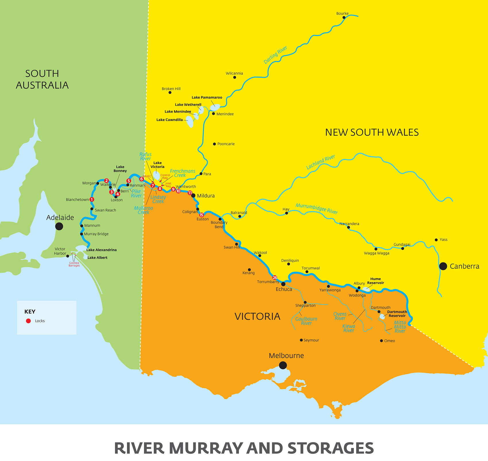
  • River Murray and Storages
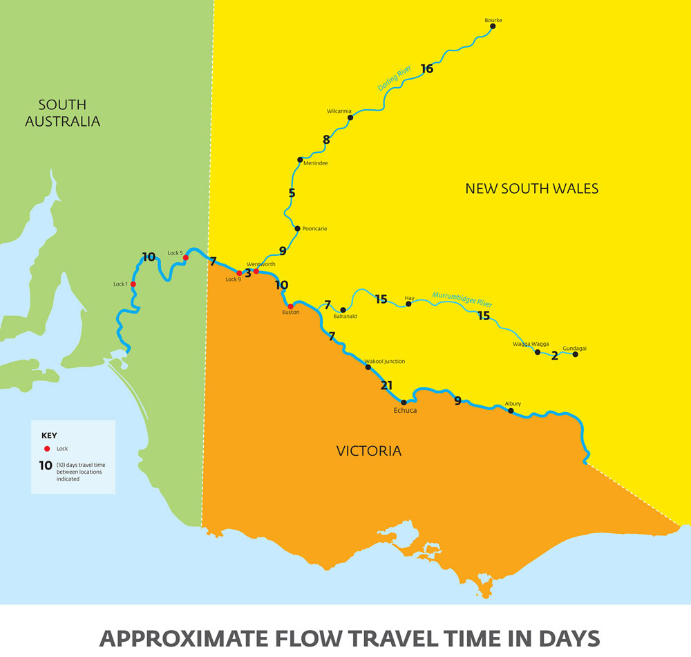
  • Approximate Flow Travel Time in Days
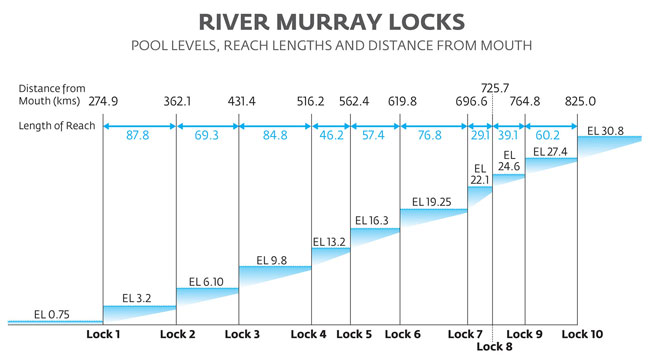
  • River Murray Locks (pool levels, reach length and distance from mouth)

Mapland

Mapland sell a range of mapping products including:

  • Topographic/Cadastral maps
  • Emergency Services and CFS Maps
  • Bushwalking maps and publications
  • Aerial photography
  • Spatial GIS data
  • Custom made maps
Acknowledgement of Country

Acknowledgement of Country

The state government acknowledges Aboriginal people as the First Peoples and Nations of the lands and waters we live and work upon and we pay our respects to their Elders past, present and emerging. We acknowledge and respect the deep spiritual connection and the relationship that Aboriginal and Torres Strait Islander people have to Country.

We work in partnership with the First Peoples of South Australia and support their Nations to take a leading role in caring for their Country.

About us

  • Reports
  • News hub
  • Vacancies
  • Contact us
  • Provide feedback

I want to

  • Apply for a grant
  • Apply for a water permit
  • Apply for an animal permit
  • Buy a map
  • Buy a parks pass
  • Report an offence
  • Volunteering

Natural resources

  • River Murray
  • Murray-Darling Basin
  • Wetlands
  • Fire management
  • Park management
  • Native vegetation
  • Coasts

Our places

  • National parks
  • Marine parks
  • Cleland Wildlife Park
  • Botanic Gardens
  • Seal Bay
  • Naracoorte Caves
  • State Flora
  • Adelaide Gaol
  • State Herbarium
  • Heritage
  • Disclaimer
  • Privacy
  • Accessibility

This site is licensed under a Creative Commons Attribution 3.0 Australia Licence.
© Copyright Department for Environment and Water 2025

  • SA Gov
  • White Ribbon Workplace
  • Green Building Council of Australia
  • Reconciliation South Australia